Sobre la legendaria Ruta 40, catorce kilómetros al norte de Santa María de Yokavil, cabecera del departamento del mismo nombre, Fuerte Quemado es el último poblado al norte de Catamarca, en el límite con Tucumán. En uno de sus cerros, por una “ventanita” de piedra se cuela el primer sol de invierno, sintetizando el valor arqueológico de los Valles Calchaquíes y una de las razones para no dejar de visitar este sitio único.
En Fuerte Quemado las calles son estrechas y la mismísima Ruta 40 le atraviesa cual si fuera un sendero más, contagiando al visitante con el andar cotidiano de un pueblo del noroeste argentino. Las casas son altas construcciones de adobe, que son un fiel testimonio de una arquitectura barroca colonial que, con la nobleza del barro y la paja, supo resguardar ancestralmente a los pobladores de la rigurosa amplitud térmica y de los movimientos sísmicos de la región.
Fuerte Quemado forma parte de los Valles Calchaquíes, que a lo largo de 520 kilómetros contiene valles y montañas de Salta, Tucumán y Catamarca; y constituyen uno de los sistemas naturales predilectos de los turistas que recorren la Argentina.
Un pasado que no se fue
La población de Fuerte Quemado no supera el medio millar de habitantes. Los relatos históricos refieren como primeros pobladores a los pueblos originarios acalianes, del período agro alfarero tardío, que supieron habitarle por cientos entre los años 850 y 1400 d.c.; hasta la llegada del Inca, que venía bajando desde el “Qosqo”, actual Cusco, Perú.
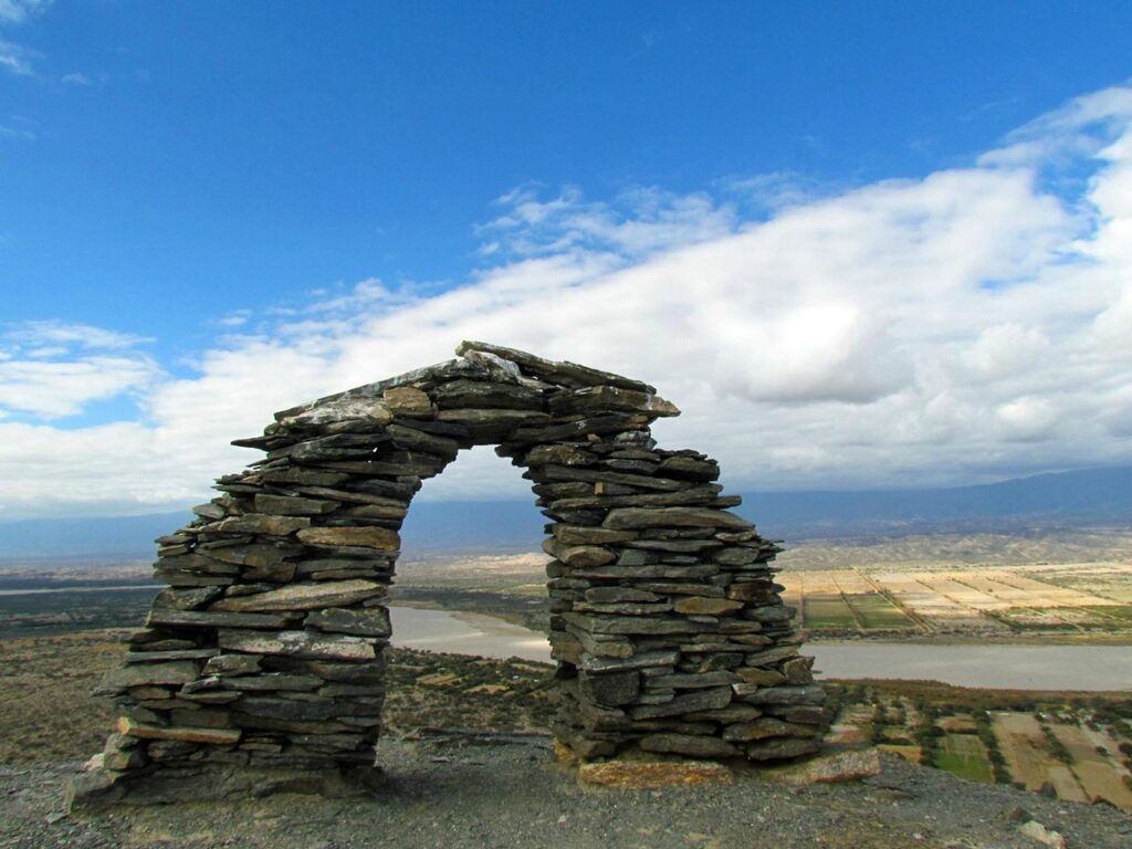
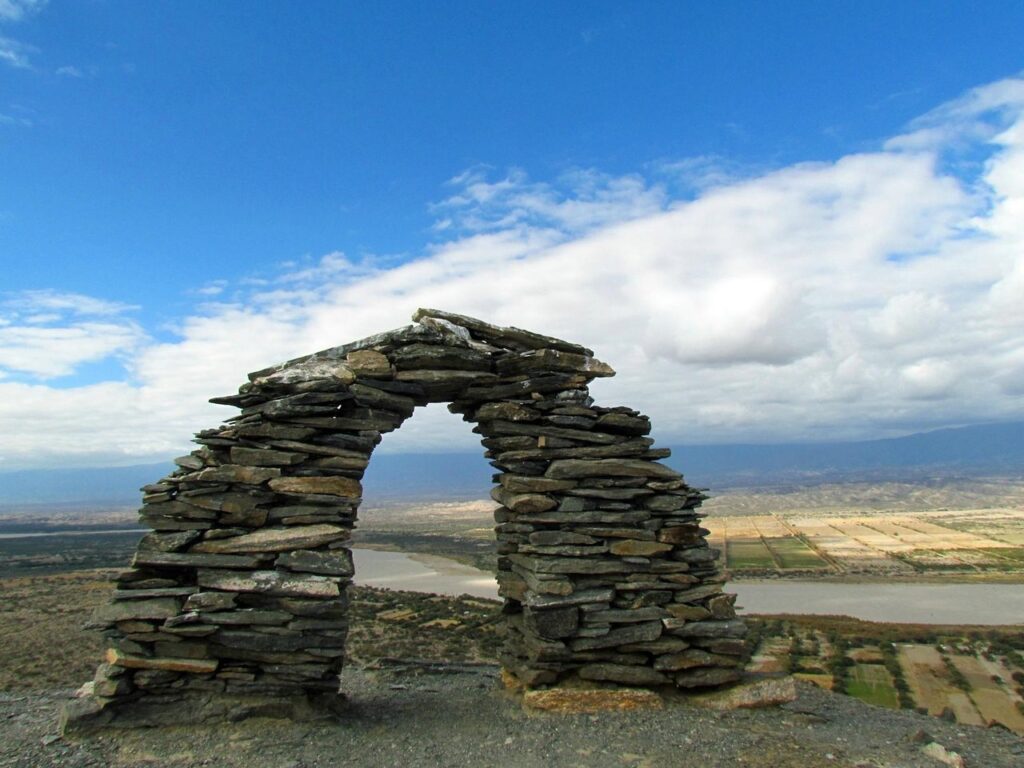
La “Ventanita” o “Intiwatana” llegó con el Inca. Se trata de un arco o portal de piedra, que se encuentra sobre la punta de un cerro, con un ojo que permite ver directamente el amanecer y por donde, de manera perfecta, cada 21 de junio, con el solsticio de invierno se cuela el primer sol de la estación; lo que los pueblos originarios llaman el “Inti Raymi”.
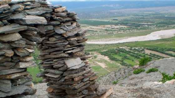
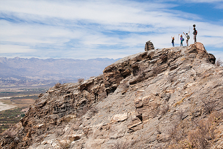
Ubicada a unos 300 metros por encima del nivel del río, “la ventanita” está construida por pircas de piedra y desde allí, además, se puede observar todo el valle de Yokavil, la población de Fuerte Quemado y sus cultivos, el río Santa María y en el horizonte, las cadenas montañosas de la región: un tesoro para los gustosos de cautivar la belleza en fotografías.
Intiwatana
Tradicionalmente, las comunidades asignaban especial importancia al primer sol del invierno. En él depositaban la esperanza de una buena cosecha; tal es así, que creían que, si ese primer sol ingresaba con toda su luz en la “ventanita”, el año que iniciaba sería provechoso para la producción.
En el Machu Picchu y en otros asentamientos incaicos hay construcciones similares. “Lugar donde se amarra el sol” o “lugar donde el año solar es moderado” son algunas de las definiciones posibles para la expresión incaica “intiwatana”, con que se conoce a la “ventanita”. En rigor, permitía observar los diferentes posicionamientos del sol y las constelaciones.
Desde la cosmovisión originaria, se entendía que el lugar en que se emplazaban estas construcciones tenía un valor energético, que permitía armonizar el cosmos con uno mismo y la tierra. Además de la “ventanita”, en Fuerte Quemado pueden encontrarse piedras con perforaciones, conocidas como morteritos, con las que también estudiaban los cielos los antiguos.
Fuerte Quemado, como tal, fue un asentamiento jesuita perteneciente a la misión de Santa María de los Ángeles de Yokavil, que en 2018 cumplió 400 años. Actualmente, solos, en pequeños grupos o con sus familias, visitantes arriban convocados por su testimonio vivo de una historia de siglos en el continente.
Ruinas ancestrales
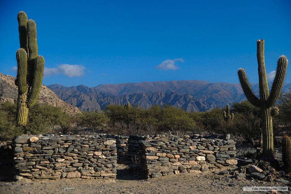
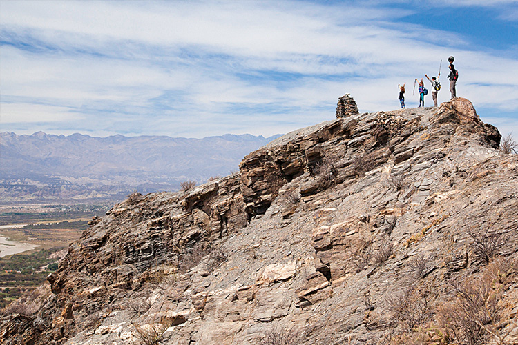
Patrimonio Histórico Provincial, Fuerte Quemado cuenta con un conjunto de ruinas en piedra, característico de los Valles Calchaquíes, que está ubicado a un kilómetro y medio de la Ruta 40 y que se conserva sin alteraciones, como sitio arqueológico de una riqueza invaluable. Se estima que Fuerte Quemado fue uno de los enclaves precolombinos más importantes de la región. Quienes llegan por el lugar, pueden recorrer el antiguo pucará y las bocaminas o socavones, de donde se extraía oro, plata y cobre; y también los escoriales de las fundiciones.
Estas ruinas ocupan una superficie aproximada de un kilómetro cuadrado, en la margen izquierda del río. Alrededor, abundan bosques de algarrobos, chañares, tuscas, jarillas y retamas. Las construcciones pertenecerían a los acalianes, que eran diaguitas, y que habrían habitado estas tierras por más de cinco siglos dejaron su huella imborrable.
Desplazándose entre las pequeñas callejuelas, el visitante puede imaginar dónde estarían los talleres para hilar la fibra fina de vicuña, los corrales de llamas, los depósitos para el acopio de granos y morteros. Viviendas con formas de herradura, canales de riego y cuadros de cultivo completan un cuadro de pinceladas históricas, en el que hay que incorporar enormes poblaciones que habrían sido desplazadas con la tercera guerra calchaquí. Y en lo alto de una loma, la “ventanita”, como mangrullo privilegiado para viajar en el tiempo.
Turismo arqueológico
En Fuerte Quemado no hay infraestructura hotelera, mas las puertas de las casas de las familias se abren gentiles a los visitantes con comidas típicas, lugar para descansar y acompañamiento para conocer las ruinas indígenas.
Tomando la Ruta 40, catorce kilómetros hacia el Sur está la cabecera del departamento, Santa María de Yokavil, con 20 mil habitantes y una mayor oferta de alojamiento e infraestructura turística de relevancia.
Sin dudas, el sitio arqueológico de Fuerte Quemado y “La Ventanita” son de las mejores propuestas turísticas del departamento Santa María, en Catamarca. Orientadas a un público amplio, del país y del exterior, invitan a practicar un turismo sustentable y responsable con el patrimonio natural e histórico, que pervive para posicionarse en el pasado con los ojos del presente.
…………………………
English Version
Fuerte Quemado: a little window towards The Calchaquies Valley

On the legendary Route 40, fourteen kilometers north of Santa María de Yokavil, head of the department of the same name, Fuerte Quemado is the last town north of Catamarca, on the border with Tucumán. On one of its hills, the first winter sun shines through a stone “window”, summarizing the archaeological value of the Calchaquí Valleys and one of the reasons not to miss visiting this unique site.
In Fuerte Quemado the streets are narrow and Route 40 itself runs through it as if it were just another path, infecting the visitor with the daily life of a town in northwest Argentina. The houses are tall adobe constructions, which are a faithful testimony of a colonial baroque architecture that, with the nobility of mud and straw, knew how to ancestrally protect the inhabitants from the rigorous thermal amplitude and seismic movements of the region.
Fuerte Quemado is part of the Calchaquíes Valleys, which along 520 kilometers contains valleys and mountains of Salta, Tucumán and Catamarca; and they constitute one of the favorite natural systems of tourists who tour Argentina.
A past that did not go away

The population of Fuerte Quemado does not exceed half a thousand inhabitants. Historical accounts refer as the first settlers to the native Acalian peoples, from the late agro-pottery period, who knew how to inhabit it by the hundreds between the years 850 and 1400 AD; until the arrival of the Inca, who was coming down from “Qosqo”, current Cusco, Peru.
The “Ventanita” or “Intiwatana” arrived with the Inca. It is a stone arch or portal, which is located on the tip of a hill, with an eye that allows you to see the dawn directly and through which, in a perfect way, every June 21, with the winter solstice, the sun sneaks in. first sun of the season; what the native peoples call the “Inti Raymi”.
Located about 300 meters above the river level, “the little window” is built by stone pircas and from there, you can also see the entire Yokavil valley, the town of Fuerte Quemado and its crops, the Santa María River and on the horizon, the mountain ranges of the region: a treasure for those who like to captivate beauty in photographs.
Intiwatana
Traditionally, communities assigned special importance to the first sun of winter. In him they placed the hope of a good harvest; So much so, that they believed that, if that first sun entered the “little window” with all its light, the year that began would be beneficial for production.
In Machu Picchu and other Inca settlements there are similar constructions. “Place where the sun is moored” or “place where the solar year is moderate” are some of the possible definitions for the Inca expression “intiwatana”, by which the “little window” is known. Strictly speaking, it allowed us to observe the different positions of the sun and the constellations.
From the original worldview, it was understood that the place where these constructions were located had an energetic value, which allowed the cosmos to be harmonized with oneself and the earth. In addition to the “little window”, in Fuerte Quemado you can find stones with perforations, known as mortars, with which the ancients also studied the heavens.
Fuerte Quemado, as such, was a Jesuit settlement belonging to the mission of Santa María de los Ángeles de Yokavil, which in 2018 turned 400 years old. Currently, alone, in small groups or with their families, visitors arrive summoned by their living testimony of a centuries-old history on the continent.
Ancient ruins
Provincial Historical Heritage, Fuerte Quemado has a set of stone ruins, characteristic of the Calchaquí Valleys, which is located one and a half kilometers from Route 40 and which is preserved without alterations, as an archaeological site of invaluable wealth. It is estimated that Fuerte Quemado was one of the most important pre-Columbian enclaves in the region. Those who arrive through the place can tour the old pucará and the mine openings or sinkholes, from where gold, silver and copper were extracted; and also the waste from the foundries.
These ruins occupy an area of approximately one square kilometer, on the left bank of the river. Around, there are forests of carob trees, chañares, tuscas, jarillas and brooms. The buildings would belong to the Acalianes, who were Diaguitas, and who would have inhabited these lands for more than five centuries, leaving their indelible mark.
Moving through the small alleys, the visitor can imagine where the workshops would be for spinning the fine vicuña fiber, the llama corrals, the warehouses for storing grains and mortars. Horseshoe-shaped homes, irrigation canals and crop fields complete a picture of historical brushstrokes, in which we must incorporate huge populations that would have been displaced with the third Calchaquí war. And at the top of a hill, the “little window”, like a privileged mound to travel through time.
Archaeological tourism
In Fuerte Quemado there is no hotel infrastructure, but the doors of the families’ houses open to visitors with typical meals, a place to rest and accompaniment to get to know the indigenous ruins.
Taking Route 40, fourteen kilometers to the South is the head of the department, Santa María de Yokavil, with 20 thousand inhabitants and a greater range of accommodation and relevant tourist infrastructure.
Without a doubt, the archaeological site of Fuerte Quemado and “La Ventanita” are among the best tourist proposals in the Santa María department, in Catamarca. Aimed at a broad public, from the country and abroad, they invite you to practice sustainable and responsible tourism with the natural and historical heritage, which survives to position yourself in the past with the eyes of the present.

